
Upgrade your project management &
decision making with a GIS solution
Streamline your project management and enhance your decision making with geographic information system (GIS) solutions. Alexander Symonds has a dedicated GIS team with experience creating meaningful maps across a range of land use, construction and infrastructure industries. Reach out to our team to see how GIS can make a difference in your project.
What is GIS and its relationship with surveying?

Land surveying measures and maps the environment using specialised technology and scanning equipment. Surveying establishes the boundaries of the environment being measured.
Geographic information systems (GIS) are the spatial systems and skills that collect and analyse this captured surveyed data. It can provide insight into the best direction for a planned development.
Using innovative modelling, GIS is used to visualise answers to complex project-specific questions such as, how big an area will be disturbed if a new transmission line is built over an area? Or what is the impact on native vegetation if a road is built through this field?
Accurate and detailed geospatial data is critical for modern day planning. GIS can provide just that.
Meaningful GIS solutions for project management and decision making
Alexander Symonds is uniquely qualified to provide unrivalled GIS solutions. Our team of GIS specialists can build targeted, custom solutions that deliver the information you need in a meaningful and effective way.
We keep up to date with the latest GIS technologies and capabilities so that we can deliver to national and international industry standards.
Targeted and scalable visualisation
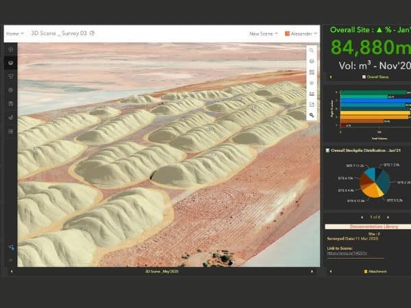
We create custom GIS web maps and products in an easy-to-digest format for your target audience. Our GIS products stream data from multiple sources, including live data. Enabling real-time data visualisation means you can make data-driven decisions on site, greatly improving your project management capabilities.
Our team is experienced in creating GIS products of all complexities and ensuring it can be scaled up or down with functionalities and data layers to meet your needs.
Simplified view
Our GIS solutions feed information from multiple streams into one, interactive product. With a focus on being user-friendly and easily accessible, our interactive GIS solutions include web applications and PDFs.
Stakeholder coordination & collaboration
Coordinating different stakeholders involved in projects presents a range of challenges. Our GIS team can help coordinate cross-platform data exchange from all stakeholders contributing to the development of your project. We also have experience maintaining central data depositories, allowing a more efficient data management system for a multi-disciplinary project.
Data analysis
We custom-design GIS products to suit your project’s unique requirements. Working closely with our customers, we design analytical tools and products that help uncover business-critical factors. These can be set up as user-friendly online GIS services, allowing continuous location insights with online analysis of geospatial data.
Custom & dynamic online web services
The GIS team uses GIS mapping software to transform data into interactive web maps. Spatial data infrastructure is now the international standard to visualise geospatial data. It offers interoperability, so these services can be accessed online by anyone, anywhere, on any device.
Online web service maps can be shared privately or publicly, and can be dynamically updated by project managers or collaboratively with your team on the ground.
Share & collaborate
Share your GIS product with stakeholders, your staff and the wider public. Our team can set permissions to control who can see your maps and data. We can also set up services on customer’s portals or host services on your behalf that will allow anyone in a team to securely interact with geospatial data in real time from anywhere in the world.
An integrated GIS approach for asset management and spatial analysis
With unrivalled expertise and technology in surveying, we provide an integrated approach to asset data capture, management, analysis and visualisation. We can maximise the capabilities of your GIS solution by leveraging our skills in boundary surveys, RPAS remote sensing, 3D laser scanning, or drone and aerial skills.
The GIS team uses the powerful Esri suite of mapping and spatial analytics software,, to visualise your data online as web services. This enables us to produce GIS solutions that can run in the cloud, on mobile devices, and on desktops.
We specialise in integrated solutions, working with and within your existing infrastructure. We can integrate the tools and apps we develop with your platforms or through integrating information with external applications like Borealis through API configurations.
GIS has countless applications across a wide range of industries and our team has the experience to provide a sophisticated, integrated GIS platform to manage your project.
As a surveying company, we have significant experience with geospatial data for infrastructure corridors, whether it be transmission lines, railway, roads, or pipelines. We excel at developing solutions that suit your unique data requirements and can be shared through different formats and platforms.
We have the technology and industry know-how to support state government infrastructure modernisation projects. Working together from concept to final delivery, we can design products that make noticeable improvements to project and asset management of complex projects and teams.
Our GIS team has extensive experience in the renewable energy sector. We have the tools and expertise to help you make intelligent, data-driven decisions that meet the approval body’s legal and constraint specifications. With live, dynamic data, this can even be done on the fly.
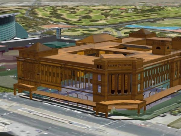
The GIS team applies innovative data visualisation techniques to enhance the understanding of construction models. Working collaboratively with the rest of the Alexander Symonds team, we can provide unparalleled insights with advanced surveying technology, 3D Laser scans and aerial and drone surveys. You can confidently make decisions about the design and construction contracts with an integrated GIS solution.
Why Choose Alexander Symonds?
Our aim is to design solutions that simplify the effort of navigating geospatial data and analysis.
We have experience producing GIS solutions in the construction and infrastructure industries and have an in-depth understanding of the stakeholders and project management requirements. Using the latest GIS technology, we can provide you with a comprehensive GIS solution that is built to your specifications.
Every project is unique and we adapt our process to suit. We build custom GIS solutions to deliver the capabilities you want by working with you to understand your objectives and identify risks. From small lease management projects to full-scale construction developments, our team can provide you with a GIS solution to make intelligent, data-driven decisions.
- Consult with a dedicated team of GIS specialists
- Improve project management with uniquely designed solutions
- Make informed, data-driven decisions
Make data-driven decisions with confidence
Let us simplify your spatial data analysis capabilities and improve your project management with a GIS solution built for you.
Request a free quote